Property Record
Hickory Rd, Woodstock, GA 30188
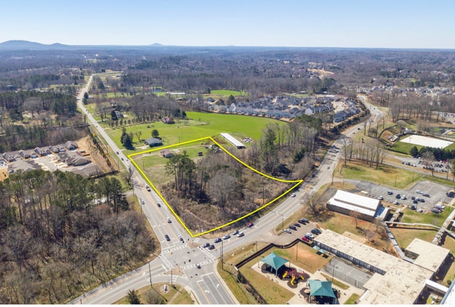
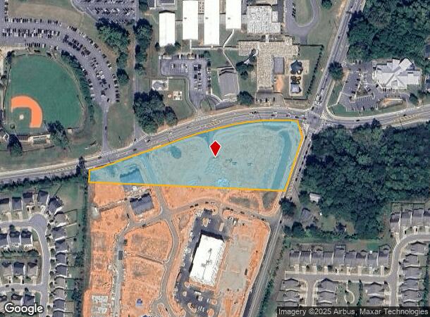
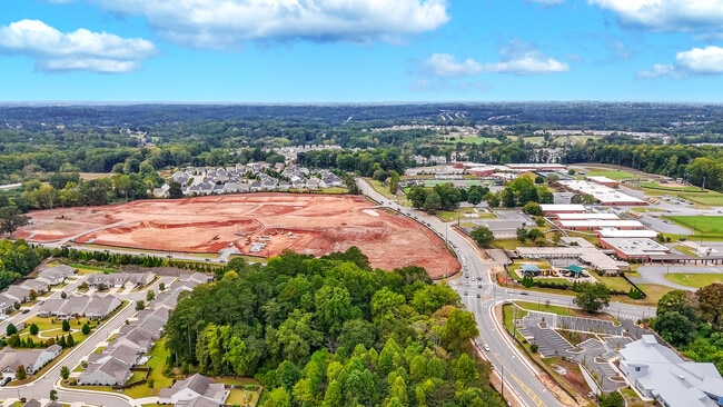

This Property Is For Sale
NEARBY LISTINGS FOR SALE OR LEASE
Property Detail
Hickory Rd
Atlanta-Sandy Springs-Roswell, GA
Carrington Farm
015N26-00000-124-000-0000
LL 325 326 15TH D
Agriculturalland
Cherokee
X
Georgia
13057C0266E
325
2025
4.23 AC
2025
Cherokee County
090911
Atlanta
1,567 SF
DEMOGRAPHICS near Hickory Rd
1 Mile
3 Mile
5 Mile
2024 Total Population
4,277
28,077
71,539
2029 Population
4,962
32,186
81,325
Pop Growth 2024-2029
+ 16.02%
+ 14.63%
+ 13.68%
Average Age
43
40
40
2024 Total Households
1,499
9,478
24,643
HH Growth 2024-2029
+ 16.01%
+ 14.75%
+ 13.87%
Median Household Inc
$126,928
$125,773
$111,538
Avg Household Size
2.80
2.90
2.90
2024 Avg HH Vehicles
2.00
2.00
2.00
Median Home Value
$457,909
$424,403
$395,643
Median Year Built
2003
2004
1999
Nearby Places
- Restaurants
- Banks
- Shops
- Fitness
- Groceries
Nearby Properties
Address
Land Use
TOTAL SIZE
Lot Size
Zoning
Address
Land Use
TOTAL SIZE
Lot Size
Zoning
611,396 SF
93.78 AC
R-40
Address
Land Use
TOTAL SIZE
Lot Size
Zoning
75,645 SF
16.76 AC
OI
Address
Land Use
TOTAL SIZE
Lot Size
Zoning
149,713 SF
36.97 AC
R-80
Address
Land Use
TOTAL SIZE
Lot Size
Zoning
134,017 SF
42.78 AC
AG
Address
Land Use
TOTAL SIZE
Lot Size
Zoning
123,941 SF
18.41 AC
GC
Address
Land Use
TOTAL SIZE
Lot Size
Zoning
78,439 SF
29.78 AC
R-40
Address
Land Use
TOTAL SIZE
Lot Size
Zoning
60,882 SF
12.94 AC
GC
Address
Land Use
TOTAL SIZE
Lot Size
Zoning
30,996 SF
2.05 AC
PDR
Address
Land Use
TOTAL SIZE
Lot Size
Zoning
57,798 SF
5.22 AC
GC
Address
Land Use
TOTAL SIZE
Lot Size
Zoning
55,778 SF
5.28 AC
GC
Address
Land Use
TOTAL SIZE
Lot Size
Zoning
24,158 SF
2.59 AC
NC
Address
Land Use
TOTAL SIZE
Lot Size
Zoning
9,712 SF
180.89 AC
PUD
Address
Land Use
TOTAL SIZE
Lot Size
Zoning
28,874 SF
4.84 AC
GC
Address
Land Use
TOTAL SIZE
Lot Size
Zoning
25,525 SF
2.62 AC
GC
Address
Land Use
TOTAL SIZE
Lot Size
Zoning
22,988 SF
5.41 AC
GC
Address
Land Use
TOTAL SIZE
Lot Size
Zoning
48,194 SF
9.02 AC
GC
Address
Land Use
TOTAL SIZE
Lot Size
Zoning
22,394 SF
4.29 AC
OI
Address
Land Use
TOTAL SIZE
Lot Size
Zoning
15,691 SF
2.52 AC
GC
Address
Land Use
TOTAL SIZE
Lot Size
Zoning
7,284 SF
62.19 AC
AG
Address
Land Use
TOTAL SIZE
Lot Size
Zoning
4,000 SF
23.54 AC
GC
Address
Land Use
TOTAL SIZE
Lot Size
Zoning
1,653 SF
11.47 AC
PDR
Address
Land Use
TOTAL SIZE
Lot Size
Zoning
7,914 SF
3 AC
GC
Address
Land Use
TOTAL SIZE
Lot Size
Zoning
13,828 SF
2.03 AC
PUD
Address
Land Use
TOTAL SIZE
Lot Size
Zoning
10,117 SF
1.56 AC
GC
Address
Land Use
TOTAL SIZE
Lot Size
Zoning
1,865 SF
2 AC
R-40
Address
Land Use
TOTAL SIZE
Lot Size
Zoning
22,027 SF
17 AC
AG
Address
Land Use
TOTAL SIZE
Lot Size
Zoning
14,779 SF
1.60 AC
GC
Address
Land Use
TOTAL SIZE
Lot Size
Zoning
9,916 SF
1.75 AC
PUD
Address
Land Use
TOTAL SIZE
Lot Size
Zoning
19,740 SF
9.37 AC
R-40
Address
Land Use
TOTAL SIZE
Lot Size
Zoning
11,938 SF
1.53 AC
GC
The World's #1 Commercial Real Estate Marketplace
Connect with us
© 2025 CoStar Group
The information above has been obtained from sources believed reliable. While we do not doubt its accuracy we have not verified it and make no guarantee, warranty or representation about it. It is your responsibility to independently confirm its accuracy and completeness. Any projections, opinions, assumptions, or estimates used are for example only and do not represent the current or future performance of the property. The value of this transaction to you depends on tax and other factors which should be evaluated by your tax, financial, and legal advisors. You and your advisors should conduct a careful, independent investigation of the property to determine to your satisfaction the suitability of the property for your needs.